Posts

Dendrology of the Klamath River

Below is my slide show including two plant species from each of the various ecosystems of the Klamath River. Only the tip of the iceberg of this incredibly biodiverse region. I got to experience both the extreme and subtle changes in habitat a few weeks ago as I drove the river from the Pacific Coast to I-5. It is quite something to experience.

Klamath River Flood Maps and Risk

Image
For this assignment I really enjoyed using FEMA's National Flood Hazard Layer (NFHL)Viewer . From the flood data research earlier in the semester, I found that the two most likely sites for flooding on the Klamath were from the confluence of the Trinity downstream to the mouth of the river at the Pacific Ocean near Klamath and Requa, CA. Its a very interactive ArcGIS site where you can follow the length of the river and it will layer in blue the possible flood plain. The maps are divided into FIRM Panels and you can zoom in and download each panel. This is the the Pacific to the Trinity River: And this is around Seiad Valley, upriver a ways: Clearly some of the files download differently, but on the site, you can zoom in all in color, and the basic blue layer of the flood plain usually is marked with the letter A. It was helpful to explore the Klamath County Flood Insurance Site to understand what the lettering meant. On this site, a landowner or homeowner can search their parcel

Key Invasive Plants of the Klamath River

Here's my slideshow outlining some of the invasive species that are being targeted in the Klamath Restoration. I was interested to learn that there are many many more in the region. It's a pretty overwhelming and sometimes disheartening issue across the nation (and the world). Philosophically sometimes you can frame non-native species through the lens that we are a global community where people and other species of plants and animals move freely throughout the world in this day and age. But when species become invasive and destructive of eco-systems, it's a deeper issue. Hard not to look at humans as invasive especially in the context of war and oppression, and obviously the greater environmental and ecological impact we have had.

Driving the Klamath (Equipment Research)

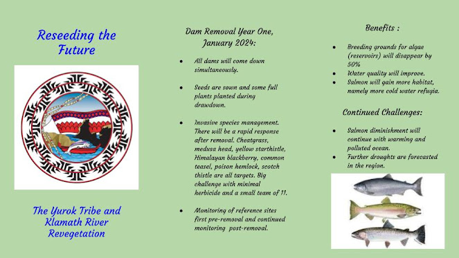
I had the time and good fortune to drive most of the length of the Klamath River last Saturday. It was a long road, and I was pretty fried by the end, but so glad I did it. Once you get up to the dams, it becomes harder and windier to make it all the way to Klamath Falls and the lakes, so sadly I ran out of time. But made it 195 miles of 257.  I decided to lightly explore my drive through a story map. I know that ESRI has updated its StoryMaps to ARCGIS, but I decided to dip my toe with the old version. Much monitoring is done through mapping software. I have used Avenza for other projects on this course, and I love the layering capabilities, the global positioning on a map, and the ways to share monitoring photos and the like. Friends who do research and monitoring also use ARCGIS Field Maps. Story Maps is also a terrific tool for use in monitoring and stewardship/conservation storytelling with the ability to map a journey, share photos and leave notes. It's user friendly and much

Watershed Special Threats or Challenges

Image
Here is a mock up of a brochure touting the Yurok Tribe's involvement in the revegetation around the dams:   This is all based on an interview I did where I sat down with Josh Chenoweth and chatted for a good hour on the the awesome work they're doing. Below is a link. Thanks Josh for taking the time!!!! https://drive.google.com/file/d/1AF5Kped6gs8eGPUWVQ91Spjcqz4Fr8Hf/view?usp=share_link

Watershed Organization Research (KRRC and The Yurok Tribe)

Here's a slideshow on the Yurok Tribe and the Klamath River Renewal Corporation. A little background and some of their collaboration. I have a meeting tomorrow with Josh Chenowith whois working first hand on the dam removal, and I'm hoping to set up a meeting soon with Amy Cordalis, lead counsel for the Yurok Tribe.

Klamath River Flood and Drought Data

Image
So, this was fun to look at the different present and historical data from the river. Coincidentally, there is A LOT of rain forecast for this week in the region, so I was interested to see what was going on on the Klamath. There actually is a flood watch but not for the river itself. Many streams and hillsides are covered in burn scars and debris from the recent fires in the area, so there is risk of tributary streams and creeks clogging and filling up but not the river itself. I looked at the the NWS link for Advanced Hydrologic Prediction  https://water.weather.gov/ahps2/index.php?wfo=mfr  and the California Nevada River Forecast Center (CNRC)  https://www.cnrfc.noaa.gov/graphicalRVF.php?id=SEIC1 . Both use NOAA data and are set up a little differently, but similarly show the present week and forecast (screenshot 1), historical flood or crest data (screenshot 2), and what kind of impacts different river levels would have on the area. I have so many screenshots below because the Klam